Park nearby Badgers cove
Ireland
Park nearby Badgers cove
Badgers cove
Dunmore East Ireland
contacts phone
:
+353
Latitude:
52.1492639
, Longitude:
-6.9932376
read more
nearest Park
70 m
Dunmore East Community Garden
3 Island Road, Dunmore East
Park
read more
285 m
Dunmore East Lost At Sea Memorial
Waterford
Park
read more
483 m
Dunmore East Woods
Nymphhall
Park
read more
526 m
Dunmore East Cliff walk Path
4 The Flatrocks, Coxtown East, Dunmore East
Park
read more
9.593 km
Lark Park
Tramore Intake
Park
read more
10.799 km
Lafcadio Hearn Japanese Gardens
Tramore House, Pond Road, Tramore
Park
read more
11.047 km
The Doneraile Walk
Doneraile Walk, Tramore West, Tramore
Park
read more
12.074 km
Mount Pleasant Green
Waterford
Park
read more
12.087 km
Viewmount Green
Waterford
Park
read more
12.124 km
Green Road Gardens
52.225027, -6.865865, Battlestown, Ramsgrange, New Ross
Park
read more
12.188 km
Farronshooneen Park
Outer Ring Road, Waterford
Park
read more
13.017 km
Deer Park Forest Trail
Unnamed Rd, Co., Waterford
Park
read more
13.67 km
Ballytruckle Green
Waterford
Park
read more
13.918 km
De La Salle Sports Ground
Irlanda
Park
Premise
Point of interest
Establishment
read more
13.918 km
De La Salle Sports Ground
Irlandia
Park
read more
13.963 km
Colclough Walled Garden
Tintern Abbey, Castleworkhouse, New Ross
Park
read more
14.08 km
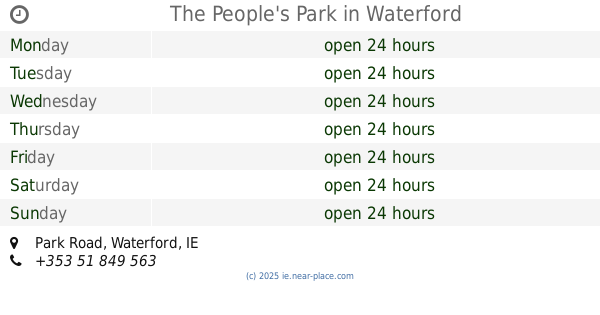
The People's Park
Park Road, Waterford
Park
read more
14.211 km
Naomh Slanaitheoir - C.L.G.
Waterford
Park
read more
14.351 km
Saint Saviour's Sports Ground
Waterford
Park
read more
14.611 km
NEW STREET GARDEN
3 New Street, Waterford
Park
read more
14.621 km
Millenium Plaza
Parade Quay Parade Quay, Waterford
Park
read more
14.797 km
Ferrybank Sports Ground
Irlanda
Park
read more
14.797 km
Ferrybank Sports Ground
Ireland
Park
read more
14.815 km
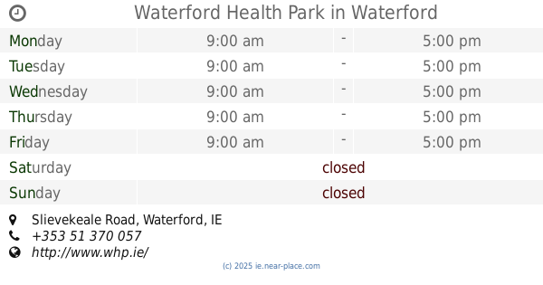
Waterford Health Park
Slievekeale Road, Waterford
Park
read more
14.955 km
Ballybricken Green
Waterford
Park
read more
📑
all categories
Accounting
Administrative area level 1
Administrative area level 2
Airport
Amusement park
Aquarium
Art gallery
Atm
Bakery
Bank
Bar
Beauty salon
Bicycle store
Book store
Bowling alley
Bus station
Cafe
Campground
Car dealer
Car rental
Car repair
Car wash
Casino
Cemetery
Church
City hall
Clothing store
Colloquial area
Convenience store
Country
Courthouse
Dentist
Department store
Doctor
Electrician
Electronics store
Embassy
Establishment
Finance
Fire station
Florist
Food
Funeral home
Furniture store
Gas station
General contractor
Grocery or supermarket
Gym
Hair care
Hardware store
Health
Hindu Temple
Home goods store
Hospital
Insurance agency
Jewelry store
Laundry
Lawyer
Library
Light rail station
Liquor store
Local government office
Locality
Locksmith
Lodging
Meal delivery
Meal takeaway
Mosque
Movie rental
Movie theater
Moving company
Museum
Natural feature
Neighborhood
Night club
Painter
Park
Parking
Pet store
Pharmacy
Physiotherapist
Place of worship
Plumber
Point of interest
Police
Political
Post office
Premise
Real estate agency
Restaurant
Roofing contractor
Route
Rv park, camping
School
Shoe store
Shopping mall
Spa
Stadium
Storage
Store
Sublocality
Subpremise
Supermarket
Synagogue
Taxi stand
Train station
Transit station
Travel agency
University
Veterinary care
Zoo
sublocality level 1
↑