Place of worship nearby Cat Stone
Ireland
Place of worship nearby Cat Stone
Cat Stone
53.490°N 7.562°W, Kellybrook, Co. Westmeath, Irland
contacts phone
:
+353
website:
uisneach.ie
Latitude:
53.4869238
, Longitude:
-7.5655067
larger map & directions
read more
nearest Place of worship
12.257 km
Ballycloghduff Sheela na Gig
Loch Lúatha
Place of worship
read more
15.616 km
Kepak ballymahon
Creevagh Beg
Place of worship
read more
18.024 km
St. Colmcille's Well
53.327271, -7.518272
Place of worship
read more
19.47 km
Multyfarnham Abbey
Multyfarnham
Place of worship
read more
22.173 km
Tullamore Kingdom Hall of Jehovah's Witnesses
Ardan
Place of worship
read more
22.621 km
Gurudwara Sahib
Blyry Lower, Athlone
Place of worship
read more
23.209 km
St Mary's Church
Saint Mary's Church, Dublin Road, Edgeworthstown
Place of worship
read more
25.62 km
St. Brigids Church
Unnamed Rd, Co.
Place of worship
read more
25.949 km
Marian Shrine
53.253535, -7.562933
Place of worship
read more
26.051 km
Dun Mhuire
Lyster Street, Athlone
Place of worship
read more
29.434 km
Knockanboy Gospel Hall, Longford
Knockanboy
Place of worship
read more
31.269 km
The Seven Blessed Wells of Killiegh
Ballinvally, Ballinasragh
Place of worship
read more
32.414 km
shay murtagh precast
Grange Beg
Place of worship
read more
32.628 km
St John's Holy Well
Knockanyconor
Place of worship
read more
33.118 km
Clonmacnoise
Clonmacnoise, Shannonbridge, Athlone
Place of worship
read more
36.058 km
Church of the Nativity of the blessed virgin mary
Frankford
Place of worship
read more
36.109 km
Convent of Mercy
53.176644, -7.726213
Place of worship
read more
43.491 km
Tisrara Church -Church of the Good Shepherd
R357
Place of worship
read more
46.56 km
St. Josephs Church
4, Ashbrook, Ballyforan
Place of worship
read more
49.295 km
KILL GRAVEYARD
9 Cherryvalley Copse, Cherryvalley, Rathmolyon
Place of worship
read more
51.507 km
Drumavaddy Community center & Church
Drumavaddy, Carrickaboy
Place of worship
read more
53.043 km
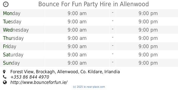
Bounce For Fun Party Hire
Forest View, Allenwood
Place of worship
read more
53.087 km
Heath Church
The Heath
Place of worship
read more
55.072 km
St. Mary's Church, Clonaphilip
Termon
Place of worship
read more
61.775 km
Baza
3 Dominic Street, Portumna
Place of worship
read more
📑
all categories
Accounting
Administrative area level 1
Administrative area level 2
Airport
Amusement park
Aquarium
Art gallery
Atm
Bakery
Bank
Bar
Beauty salon
Bicycle store
Book store
Bowling alley
Bus station
Cafe
Campground
Car dealer
Car rental
Car repair
Car wash
Casino
Cemetery
Church
City hall
Clothing store
Colloquial area
Convenience store
Country
Courthouse
Dentist
Department store
Doctor
Electrician
Electronics store
Embassy
Establishment
Finance
Fire station
Florist
Food
Funeral home
Furniture store
Gas station
General contractor
Grocery or supermarket
Gym
Hair care
Hardware store
Health
Hindu Temple
Home goods store
Hospital
Insurance agency
Jewelry store
Laundry
Lawyer
Library
Light rail station
Liquor store
Local government office
Locality
Locksmith
Lodging
Meal delivery
Meal takeaway
Mosque
Movie rental
Movie theater
Moving company
Museum
Natural feature
Neighborhood
Night club
Painter
Park
Parking
Pet store
Pharmacy
Physiotherapist
Place of worship
Plumber
Point of interest
Police
Political
Post office
Premise
Real estate agency
Restaurant
Roofing contractor
Route
Rv park, camping
School
Shoe store
Shopping mall
Spa
Stadium
Storage
Store
Sublocality
Subpremise
Supermarket
Synagogue
Taxi stand
Train station
Transit station
Travel agency
University
Veterinary care
Zoo
sublocality level 1
↑